 |
 |
| WELCOME | MAP | SCENIC BYWAY THROUGH THE MOUNTAIN ROUTE | SCENIC BYWAY THROUGH THE MORA RIVER VALLEY | SCENIC BYWAY THROUGH THE SANTA FE- LAS VAGAS CORRIDOR | SCENIC BYWAY THROUGH THE CIMARRON CUTOFF | HISTORY | POINTS OF INTEREST | Contact Us | DRIVING DIRECTIONS | WEBSITE LINKS | EVENTS |
| SCENIC BYWAY THROUGH THE SANTA FE- LAS VAGAS CORRIDOR |
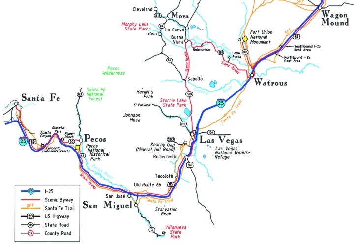
The Santa Fe-Las Vegas Corridor is drawn in red on the map. Except for a small portion of freeway, the Scenic Byway stretches all the way from Santa Fe to Las Vegas
New Mexico is fortunate to have the most beautiful and the most intriguing portions of the entire Santa Fe Trail, and that of course includes the one-of-a-kind city of Santa Fe.
After seeing the sights of Santa Fe, you can head out to explore the Santa Fe Trail for yourself and by traveling the Scenic Byway follow very close to the route of the Santa Fe Trail (SFT) as it wound through this enchanted land.
This portion of the Santa Fe Trail National Scenic Byway begins where the Santa Fe Trail officially ended, at the Historic Santa Fe Plaza in downtown Santa Fe. Wagon trains arrived in the Plaza on the street appropriately named the Old Santa Fe Trail. The final block of the Old Santa Fe Trail is a one-way street, though, so you will have to go around the block before heading south along the Old Santa Fe Trail, (County Road 67).
About a mile south of the Plaza, the road forks. The Old Santa Fe Trail veers off to the left and to the right is the beginning of the street named the Old Pecos Trail. Take the Old Santa Fe Trail as it turns left and starts its climb toward Museum Hill. For the final few miles of the 7.5 mile journey along the Old Santa Fe Trail, the actual Santa Fe Trail meanders along side your path. At Two Trails Rd (County Road 67c), the Scenic Byway turns right (south) toward I-25. Just as you turn south onto CO 67c, you immediately cross the path of the actual SFT.
Less than a mile south on CO 67c, before reaching the freeway, turn east onto US Hwy 85, the Old Las Vegas Highway. The Scenic Byway follows Hwy 85 east for 7 miles to the community of Cañoncito. Cañoncito was once the location of Johnson's Ranch, a historic stop on the Santa Fe Trail and a famous Civil War site. To jump to the next leg of the Scenic Byway, get onto northbound I-25 at Cañoncito, and follow the freeway for the five mile journey through Glorieta Pass. The historic Santa Fe Trail winds along the bottom of the canyon below the freeway. To understand Apache Canyon & Glorieta Pass, see the back side of this map, the History of the Santa Fe-Las Vegas Corridor. The SFT is shown in gold on the map.
Exit I-25 at the first opportunity (Glorieta Exit 299) and you are back on the Scenic Byway. Proceed west along State Road NM 50. Within half a mile you will enter another Civil War battlefield. After another half mile you will pass Pigeon Ranch, now a nondescript adobe building sitting adjacent to the road on the left (north) side. This building was once part of a much larger complex that saw a lot of wagon traffic on the Santa Fe Trail and a lot of bloodshed during the Civil War. The building served as a temporary hospital and in one room the bodies of those who died in battle were stacked from floor to ceiling.
One half mile east from Pigeon Ranch, toward the town of Pecos, is a little pullout on the north side of the road where two markers commemorate the battles fought and the lives lost during those battles.
The Scenic Byway continues east to Main Street in the town of Pecos. To the north are the Pecos Wilderness and the Santa Fe National Forest. Both offer many opportunities for outdoor activities. The Scenic Byway turns south on Main Street (NM 63) to the Pecos National Historical Park. The Park is the best place to find out about the Pueblo at Pecos, the Santa Fe Trail and the Civil War battles.
From the Pecos National Historical Park, the Scenic Byway continues south on NM 63 to the town of Rowe where you will cross under the freeway and continue on to NM 34. Take NM 34 toward Las Vegas. NM 34 remains on the south side of I-25 until reaching the village of San Jose and crosses back over the freeway to become US Hwy 84, the Old Las Vegas Highway. Prior to 1938, this stretch of road was a segment of the famed Route 66.
The Scenic Byway passes to the north of San José and San Miguel, both popular places for Santa Fe Trail wagons to cross the Pecos River. The Byway then leads directly through the town of Tecoloté, another Santa Fe Trail river crossing. When reaching Romeroville, US 84 turns south. At this junction, once again cross over I-25 and take the frontage road (US Hwy 85) northbound for the remainder of the trip to Las Vegas. Just before reaching Las Vegas, you will pass to the east of Kearny Gap (now accessed by NM Hwy 283 - Mineral Hill Road) a natural mountain pass where Santa Fe Trail wagons crossed the mountain ridge. The Scenic Byway continues north on US Hwy 85, crosses under the freeway and follows Grand Avenue into the city of Las Vegas. There are four segments to the Scenic Byway. The next portion is the Mora River Valley which begins in Las Vegas and ends at Fort Union.